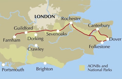
Anglotopia Photos
  • Огляд
    Discovery
    • Недавні
    • Популярні
    • Популярні
    Зміст
    • Зображень
    • Videos
    • Animated
    • Tags
    • Альбомів
    • Користувачів
    Top Tags
    Red Arrows HMS Victory HMS Warrior Mary Rose Portsmouth Portsmouth Historic Dockyard London Abandoned Britain Cumbria Stately Homes National Trust Hardknott Roman Fort Roman Britain Berkeley Castle Abandoned Tube Down Street Hidden London Cotswolds 1899 Henry John Feasey Westminster Abbey Blenheim Palace Churchill Dorset Oxfordshire Scotney Castle Tyneham Castles Gloucestershire Quintin Lake
  • Випадкове
  • Пошук
  • Розширений пошук
  • Завантаження
  • Вхід
  • UK
    • العربية
    • Български
    • Bosanski
    • Сatalà
    • Čeština
    • Dansk
    • Deutsch
    • Deutsch (Deutschland)
    • Ελληνικά
    • English
    • Español
    • Eesti (Eesti)
    • فارسی
    • Suomi
    • Français
    • עברית
    • Hrvatski
    • Magyar
    • Bahasa Indonesia
    • Italiano
    • 日本語
    • 한국어
    • Lietuvių (Lietuva)
    • ‪Norsk Bokmål‬
    • Nederlands
    • Polski
    • Português
    • Português (Brasil)
    • Română
    • Русский
    • Slovenčina
    • Српски
    • Svenska
    • ไทย
    • Türkçe
    • Українська
    • Tiếng Việt
    • 简体中文
    • 繁體中文
  • Інформація
    • API
    • Плаґін
    • Terms of service
    • Privacy
    • Contact

Quintin Lake

Tag

Нові
  • Нові
  • Старі
  • Найпопулярніші
  • Найбільш сподобались
  • AZ
Screenshot-2025-05-06-at-22.18.08.png
Screenshot 2025 05 06 at 22.18.08
by Jonathan
the-national-trails-overview-map_W1400_H1050_Mletterbox_LBfff.jpg
the national trails overview map W1400 H1050 Mletterbox LBfff
by Jonathan
the-cotswold-way-map-booklet-location-map_W1400_H1050_Mletterbox_LBfff.jpg
the cotswold way map booklet location map W1400 H1050 Mletterbox LBfff
by Jonathan
Perimeter_spread_26-1536x848.jpg
Perimeter spread 26 1536x848
by Jonathan
Perimeter_spread_20-1536x848.jpg
Perimeter spread 20 1536x848
by Jonathan
Perimeter_spread_17-1536x848.jpg
Perimeter spread 17 1536x848
by Jonathan
Perimeter_spread_16-1536x848.jpg
Perimeter spread 16 1536x848
by Jonathan
OUEC-984.jpg
OUEC 984
by Jonathan
OUEC-11.jpg
Light & Ice: East Greenland Landscape
by Jonathan
OUEC-10.jpg
Light & Ice: East Greenland Landscape
by Jonathan
OUEC-09.jpg
Light & Ice: East Greenland Landscape
by Jonathan
OUEC-08.jpg
Light & Ice: East Greenland Landscape
by Jonathan
OUEC-03.jpg
OUEC 03
by Jonathan
north-downs-way-map-booklet-location-map_W1400_H1050_Mletterbox_LBfff.jpg
north downs way map booklet location map W1400 H1050 Mletterbox LBfff
by Jonathan
IMG_9963.jpg
IMG 9963
by Jonathan
IMG_1934.jpg
IMG 1934
by Jonathan
hadrians-wall-path-location-map_W1400_H1050_Mletterbox_LBfff.jpg
hadrians wall path location map W1400 H1050 Mletterbox LBfff
by Jonathan
England--Wales-Mountains-Nutalls-Progress7.jpg
England & Wales Mountains Nutalls Progress7
by Jonathan
Greenland_2006_NM_100.jpg
Light & Ice: East Greenland Landscape
by Jonathan
C0152657-Geological_map_of_the_British_Isles.jpg
C015/2657
by Jonathan
BESNamibia-038.jpg
Mahmood & Khaled rest after trekking amongst El-Khiyam "The Tent
by Jonathan
BESNamibia-032.jpg
BESNamibia 032
by Jonathan
BESNamibia-030.jpg
Thames Waters 169 Miles downstream (Houses of Parliament, London
by Jonathan
BESNamibia-023.jpg
Thames Waters 15 Miles downstream (near Water eaton footbridge,
by Jonathan
BESNamibia-022.jpg
Thames Waters 5 Miles downstream (near Ashton Keynes). Thames Pa
by Jonathan
BESNamibia-021.jpg
Thames Waters 2 Miles downstream (near Kemble). Thames Path, Eng
by Jonathan
BESNamibia-020.jpg
Thames Waters 1/2 Mile downstream (near Kemble). Thames Path, En
by Jonathan
990_BCmap.jpg
990 BCmap
by Jonathan
453-Purfleet-LondonCityAirport-02.jpg
Now, where do I begin! The first official notice to greet the pe
by Jonathan
434-PointClear-Colchester-01.jpg
Bradwell nuclear power station from Point Clear, Essex, England.
by Jonathan
408-Hunstanton-TitchwellMarsh-15.jpg
Camp at Titchwell March, Norfolk, England.
by Jonathan
392-Atwick-Tunstall-10.jpg
Jolly Roger. Holderness, East Riding of Yorkshire, England.
by Jonathan
385-SouthGare-Skinningrove-17.jpg
Redcar Steelworks from Coatham Sands III, North Yorkshire, Engla
by Jonathan
385-SouthGare-Skinningrove-03.jpg
Redcar Steelworks and the fishing huts at South Gare II, North Y
by Jonathan
384-Middlesbrough-SouthGare-14.jpg
The unique and charismatic Dorman Long tower was demolished at 2
by Jonathan
379-Newcastle-SouterLighthouse-39.jpg
Fabrication of wind turbine jackets at Wallsend by the Tyne from
by Jonathan
378-WhitelyBay-Newcastle-15.jpg
Wind turbine jackets by the Tyne, Wallsend, North Tyneside, Engl
by Jonathan
376-Amble-NewbigginbytheSea-16.jpg
Riders I. Druridge Bay, Northumberland, England.
by Jonathan
376-Amble-NewbigginbytheSea-10.jpg
Druridge Bay, Northumberland, England.
by Jonathan
373-Bamburgh-SnookPoint-03.jpg
First Light at Bamburgh Castle, Northumberland, England.
by Jonathan
370-Berwick-upon-Tweed-HolyIsland-40.jpg
Moonlit markers I, pilgrim's path to Lindisfarne, Northumberland
by Jonathan
370-Berwick-upon-Tweed-HolyIsland-36.jpg
Shelter on the pilgrim's path to the Holy Island of Lindisfarne,
by Jonathan
363-Edinburgh-Musselburgh-43.jpg
Atop the rock, Edinburgh, Scotland.
by Jonathan
363-Edinburgh-Musselburgh-22.jpg
Winters morning at Salisbury Crags, Edinburgh, Scotland.
by Jonathan
363-Edinburgh-Musselburgh-16.jpg
Edinburgh Spires, Scotland.
by Jonathan
363-Edinburgh-Musselburgh-05.jpg
Edinburgh chimneys I, Scotland.
by Jonathan
363-Edinburgh-Musselburgh-01.jpg
Waiting for sunrise. Arthur's Seat, Edinburgh, Scotland.
by Jonathan
309-CapeWrath-CapeWrathFiringRange-42.jpg
Spartan Armoured Personnel Carrier, Cape Wrath Bombing Range, Su
by Jonathan
309-CapeWrath-CapeWrathFiringRange-09.jpg
Cl Kearvaig and Cl Mr, the highest vertical sea cliffs in
by Jonathan
276-Runival-GlenArnisdale-03.jpg
Skiary, Loch Hourn from Knoydart, Scotland.
by Jonathan
  • 1
Завантажити ще

Немає елементів для відображення.

Коди для вбудовування
Поділитися

__privacy_notes__